Top 3 Apps to Watch Satellite Images – New and Old Images
Have you ever imagined being able to look at any place in the world through satellite images?
Countries, cities, and even your own house?
Now, with the help of apps, you can explore old or recent images from anywhere. It’s like taking a real journey through time!
It’s truly amazing and even a bit nostalgic to remember certain places that have marked our lives, but that logically changed over time.
Technology can provide you with this wonderful experience.
To relive moments from home, we’ve listed three top satellite image apps and explained how to view places from the past. Get ready for the journey!
Google Maps
That Google Maps is one of the most used platforms in the world for viewing satellite images is no news.
What many don’t know is that it can also be used for a “time travel” experience. It might seem unbelievable or out of reality, but believe me, it’s totally possible.
Google Maps has a feature well-known by all, the Street View. With it, we can navigate streets, avenues, and much more. Using this same feature, we can access old images.

You’re probably wondering now, how is this possible? Well, the answer is quite simple.
Google Maps constantly updates the images available on the platform, but even so, the app manages to keep old images of places in the system. This way, we can walk through places that marked our lives and see exactly how they were years ago.
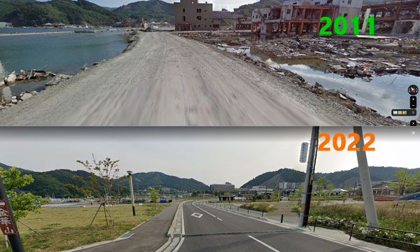
In the image below we can see the city of Onagawa Japan in the year 2011 after the tsunami, and the same place 11 years later.

After reading all of this, you surely want to experience firsthand how all of this works, right? So, check out the complete step-by-step guide to “go back in time”:
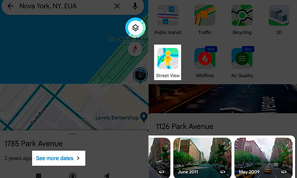
- Open Google Maps on your phone. If it’s not installed, go to your device’s app store and download it.
- After opening the app, type the desired location or a specific address in the search bar.
- Then, tap on “Layers,” located at the top of the screen (white circle).
- Select “Street View,” and then click on the “X” to exit.
- Click on any blue line or specific point you want to see.
- Then, tap on the “View more dates” link. Not all places on Google Maps have this link.
- At the bottom of the screen, select an image in the carousel.
- There you go! Now, enjoy your journey.
The app is available for Android and iOS.
Waze
Just like Google Maps, Waze also allows you to see satellite images on your phone. The difference is that many users specifically use it to receive traffic information. Similarly, the app provides weather information, alert notifications, and traffic conditions. All to help users get to their destination faster and safer through the best route.
Maps.me
And finally, we have Maps.me, which is also an excellent alternative to access satellite images. With it, users can check different routes and even download maps to use offline. The app also offers other interesting features, such as saving favorite places, conducting searches without using the internet, sharing location, and much more.
Available for Android and iOS.
See how easy it is to go back in time? Explore all the changes on your street or even in your city. Remember unforgettable places and enjoy the experience.
With these amazing apps, exploring the past has never been easier. Whether you’re revisiting your childhood neighborhood or seeing how places around the world have evolved, the journey is both fun and nostalgic. So, go ahead, download the apps, and take your own trip through time.
Afterward, tell me how your journey was. And don’t forget to share your favorite discoveries!
 AFCON 2025 Live on Mobile: Which Apps to Use
Feel the full intensity of African football on your screen, watching every decisive moment of AFCON 2025 live without relying on TV or strict schedules. Ad […]
Keep reading How to Watch URC 2025-26 Live on Android or iPhone?
Are you set to watch all the heart-pounding action of the United Rugby Championship’s 2025-26 season directly on your mobile device? Ad The URC features elite […]
Keep reading Meet Apps That Read Nutrition Labels for a Healthy Diet
Reading nutritional labels can be confusing, but with the right apps, you can understand them quickly and eat more consciously. Ad The nutrition labels may seem […]
Keep reading

